
- Boat Insurance
- Boat Browser
- Boating Courses
- Boat Registration
- Boating License
-
Boating Safety
Equipment
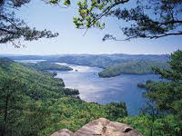
| Lake Jocassee The State of South Carolina and Duke Power created this reservoir in 1973 by impounding the waters from four rivers -- Whitewater, Thompson, Horsepasture, and Toxaway. The waters from Lake Jocassee flow into the Keowee River before it forms Lake Keowee. This popular recreation area contains little development along its 75 miles of shoreline, and anglers can capture trout here, as well as bass and other native species. Located near a state park and the towns of Walhalla and Clemson, visitors can enjoy city life as well as a vast rural environment. Visitors to this lake can enjoy sight-seeing, boating, paddling, scuba diving, hiking, hunting, waterfall tours, and some of the best fishing in the entire state. Fishing Duke Energy consistently stocked brown and rainbow trout and smallmouth bass from 2001 to 2008. No fish attractors have been established, and a fishing loaner tackle program does not exist for this lake. |
Search Lake Jocassee Resources |
 Coordinates:
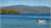
| Boating Devils Fork State Park provides the only public access point to the lake, and the only way campers can reach the Double Springs Camp Area in Oconee County near the Pickens County line is by boat. This ramp, as well as three other ramps, are all located in Oconee County. |
|
|
Lodging Devils Fork State Park provides overnight camping and villas for guests who want to stay at the north end of Lake Jocassee near the North Carolina state line. Table Rock State Park also has accommodations, and it is located to the east by about 26 miles. However, with mountainous roads, the travel to that park can take over an hour. Both Oconee and Pickens Counties contain accommodations that range from more camping areas to hotels, B&Bs, and resorts. Review the Lake Resource Guide for additional lodging. Communities Lake Jocassee extends over Oconee and Pickens Counties, and is located in far northwest South Carolina near the North Carolina border. The lake is surrounded by the Nantahala National Forest to the north and west, and by the Jocassee Gorges management Area to the east. The closest towns include Walhalla, Seneca, Clemson, Central, and Pickens, and the closest airport is located in Greenville, which is located approximately two hours from the lake. A private airport is located in Pickens County. Review the Lake Resource Guide for additional lodging. |
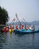
Fun times at Lake Jocassee
|
| Average Temperatures | Jan | Feb | Mar | Apr | May | Jun | Jul | Aug | Sep | Oct | Nov | Dec |
|---|---|---|---|---|---|---|---|---|---|---|---|---|
| Avg. High 51 | Avg. High 56 | Avg. High 64 | Avg. High 72 | Avg. High 79 | Avg. High 85 | Avg. High 88 | Avg. High 86 | Avg. High 81 | Avg. High 72 | Avg. High 63 | Avg. High 53 | |
| Avg. Low 25 | Avg. Low 29 | Avg. Low 34 | Avg. Low 41 | Avg. Low 51 | Avg. Low 60 | Avg. Low 64 | Avg. Low 64 | Avg. Low 57 | Avg. Low 45 | Avg. Low 36 | Avg. Low 28 |