
- Boat Insurance
- Boat Browser
- Boating Courses
- Boat Registration
- Boating License
-
Boating Safety
Equipment
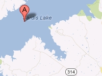
| Sardis Lake Sardis Lake is a reservoir located along the Little Tallahatchie River in northern Mississippi. Located near Sardis and an hour southeast of Memphis, Tennessee, this lake was the first of four reservoirs developed by the U.S. Army Corps of Engineers in the Yazoo Headwaters Project, which includes Grenada Lake, Enid Lake, and Arkabutla Lake. Sardis lake is notable for its successful flood control capacity, which means the lake is drawn down to approximately 9,800 acres during the fall and winter to allow room for spring rains. Normal capacity is 32,400 acres, which residents and visitors use for water skiing, boating, swimming, and fishing. The lake and its surrounding recreation areas extend over 98,000 acres. Sardis Lake is divided into "upper" and "lower" lake areas. The lower lake is approximately 425 acres, which is not included in the 32,400 upper lake summer pool acreage. Fishing |
Search Sardis Lake Resources |
 Coordinates:
| Boating Boat ramps are located at twelve of the sixteen available recreation areas, and Clear Creek offers a fish cleaning station. One ramp is located near the dam at the lower lake, and all other ramps are located around the upper lake. A new full-service marina with slips is available on Blackjack Road near John W. Kyle State Park. Expect limited ramp access during winter months as the lake is drawn down in expectation of spring rains. |
|
Lodging Campers can enjoy cabins and RV and tent camping at John W. Kyle State Park, located on the lake's northwestern shore via I-55 at exit 22 on Highway 315. If you don't mind an hour's drive to Holly Springs National Forest, you'll find a seasonal campground at the 260-acre Chewalla Lake in the north end of that forest. The U.S. Army Corps of Engineers also provides electric and non-electric camp sites at Beach Point, Clear Creek, Graham Lake, Hays Crossing, Hurricane Landing, Lespedeza Point, Lower Lake, Pats Bluff, Teckville, and Wyatt Crossing. Affordable hotels are available at both Sardis on I-55 and in Oxford, located just miles from the lake's south shores via Highways 6 or 7. Visitors also can find plenty of lodging opportunities in Memphis, Tennessee, located just an hour from the lake. Review the Lake Resource Guide for additional lodging. Communities Sardis Lake extends across Lafayette, Panola, and Marshall Counties in northern Mississippi. Located about ten miles from Sardis, this lake also is popular with University of Mississippi students from nearby Oxford. The closest major airport is located in Memphis, Tennessee, about 50 miles from Sardis. |
Fun times at Sardis Lake
|


| Average Temperatures | Jan | Feb | Mar | Apr | May | Jun | Jul | Aug | Sep | Oct | Nov | Dec |
|---|---|---|---|---|---|---|---|---|---|---|---|---|
| Avg. High 51 | Avg. High 56 | Avg. High 65 | Avg. High 74 | Avg. High 81 | Avg. High 88 | Avg. High 91 | Avg. High 91 | Avg. High 85 | Avg. High 75 | Avg. High 65 | Avg. High 54 | |
| Avg. Low 30 | Avg. Low 33 | Avg. Low 40 | Avg. Low 48 | Avg. Low 59 | Avg. Low 67 | Avg. Low 70 | Avg. Low 69 | Avg. Low 61 | Avg. Low 49 | Avg. Low 41 | Avg. Low 32 |