
- Boat Insurance
- Boat Browser
- Boating Courses
- Boat Registration
- Boating License
-
Boating Safety
Equipment
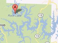
| Table Rock Lake In a chain of four man-made lakes which include Arkansas' Beaver Lake; Missouri's Lake Taneycomo; Bull Shoals Lake, which lies farthest downstream in both Arkansas and Missouri; Table Rock Lake, which also straddles the Missouri, Arkansas border provides 43,100 acres of consistently warm water contained by an 800-mile shoreline in southwest Missouri and northwest Arkansas. Table Rock Lake, created by the building of the third of four dams on the White River, the 350 foot Table Rock Dam built in 1958 by the US Army Corps of Engineers for flood protection and power generation, is known as one of the best fishing lake in the United States. One of the consequences of being a power-generating body of water includes the fact that the water stays consistently warm. With help by the warmth from the summer sun, Table Rock Lake stays around 80 degrees Fahrenheit all season long. Table Rock Lake's reputation for being clean, clear, deep and warm brings thousands of visitors every year who enjoy fishing, boating, scuba diving in deep clear waters, para-sailing, water skiing and most any other water sport. Daily showboat cruises provide food, a show, and sightseeing while excursions on a 48-foot sailing catamaran invite passengers to help crew the boat. Fishing Bluffs, gravel, rocks and cedar trees comprise the shoreline, which provides excellent habitat for large and smallmouth bass, white bass, crappie, bluegill, bullhead, carp, walleye and catfish, among other varieties of game fish. Table Rock Lake has produced many record sized fish of diverse species. In 2004, Mark Fann caught a five-pound ten-ounce Hybrid Black Bass and in 2002, three record fish were caught: A four-pound three-ounce Smallmouth Bass, a five-pound six-ounce White Bass and a 139-pound four-ounce Paddle-fish. When fishing from shore near the dam, be sure to abide the sounding of the horn and get out of the water. The horn indicates that power generation is about to begin, which causes a rapid rise in the water depth and increase in the speed of the current. The water can rise several feet in a matter of minutes. |
Search Table Rock Lake Resources |
 Coordinates:
| Boating Table Rock Lake welcomes all boat and motor types and sizes and provides many public boat launch ramps that offer easy access to the water from many different places around the lake. Numerous full-service marinas provide boat rentals, boating and fishing supplies, docks, slips, fuel, groceries and more all around the lake. |
|
Lodging Table Rock Lake lodging options include campgrounds, cottages, cabins, and over 100 resorts along the lake's shore offer styles from rustic to luxurious from which to choose. The Lake Resource Guide offers additional information on lodging and other facilities in the area. Communities Arkansas' closest major city to Table Rock Lake is Fayetteville. Other nearby cities and towns: Eureka Springs, Rogers, Bentonville, Springdale and Harrison. Table Rock Lake flows through parts of Carroll and Boone counties in Arkansas |
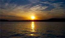
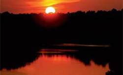
Fun times at Table Rock Lake
|
| Average Temperatures | Jan | Feb | Mar | Apr | May | Jun | Jul | Aug | Sep | Oct | Nov | Dec |
|---|---|---|---|---|---|---|---|---|---|---|---|---|
| Avg. High 45 | Avg. High 50 | Avg. High 56 | Avg. High 69 | Avg. High 76 | Avg. High 86 | Avg. High 89 | Avg. High 85 | Avg. High 81 | Avg. High 71 | Avg. High 59 | Avg. High 46 | |
| Avg. Low 23 | Avg. Low 28 | Avg. Low 33 | Avg. Low 44 | Avg. Low 52 | Avg. Low 66 | Avg. Low 65 | Avg. Low 64 | Avg. Low 55 | Avg. Low 45 | Avg. Low 36 | Avg. Low 27 |