
- Boat Insurance
- Boat Browser
- Boating Courses
- Boat Registration
- Boating License
-
Boating Safety
Equipment
| Lake Greeson Lake Greeson is a beautiful clear lake that was created in 1950 with the Narrows Dam, which impounds the Little Missouri River. Noted for its scenery and great fishing, this reservoir is surrounded by fifteen parks that provide recreational opportunities for the entire family. This reservoir was known as "Narrows Lake" until 1976, when it was renamed for the man who envisioned this flood control effort, Martin White Greeson. Although Greeson was practical in his efforts, this lake also provides numerous reasons for visiting. This 7,000-acre reservoir and its surrounding 134 miles of shoreline are geared to hikers, boaters, anglers, hunters, bird watchers, and bicyclists. ATV fans can enjoy Bear Creek Trail, the only off-road trail in the Arkansas trail system that is open all year long. Located north of Murfreesboro in the foothills of the Ouachita Mountains, Lake Greeson offers tons of amenities in an otherwise rural setting. Visitors can find plenty of campgrounds, playgrounds, swimming areas, and picnic sites. Boaters can enjoy houseboat rentals, fishing docks, at least ten boat ramps, and plentiful marinas. Two private resorts also are located at this lake. Fishing |
Search Lake Greeson Resources |
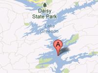 Coordinates:
| Boating Daisy State Park provides solo and tandem kayak rentals, but the clear waters in this lake also provide opportunities for water skiing, tubing, PWCs, cruising, and fishing. Eight boat ramps are located around the lake for easy access. Four marinas supply boaters with fuel, food, bait and tackle, and boat rentals. |
|
Lodging Daisy State Park offers 103 tent camp sites ranging from Class A to Class D, and many of them have a water view. The Army Corps of Engineers also manages eleven campgrounds with a total of 408 camp sites. Many of these sites offer complete amenities, including electric and water hook-ups, showers, boat ramps, and swimming areas. Two of the marinas at Lake Greeson also provide modern cabins for overnight to extended stays. Crater of Diamonds State Park is located just south of Murfreesboro, less than an hour away. This park offers 52 camp sites including 47 that provides electric and water hook-up and room for RVs. This park also provides the only place in the world where the public can search for diamonds. If you find some, they are yours to keep! Pike County offers plenty of other lodging opportunities, too, including cottages, cabins, motels, inns, retreats, and vacation rentals. Review the Lake Resource Guide for additional lodging. Communities Lake Greeson is located in Pike County, Arkansas, near the towns of Glenwood, Kirby, and Murfreesboro. The closest airport is located at Hot Springs, which is 55 miles from the center of Murfreesboro. Texarkana also offers another airport option at 68 miles from Murfreesboro. Murfreesboro is located about seven miles south of the Narrows Dam site. |
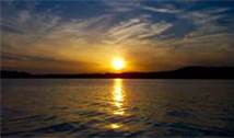
Fun times at Lake Greeson
|
| Average Temperatures | Jan | Feb | Mar | Apr | May | Jun | Jul | Aug | Sep | Oct | Nov | Dec |
|---|---|---|---|---|---|---|---|---|---|---|---|---|
| Avg. High 52 | Avg. High 57 | Avg. High 65 | Avg. High 73 | Avg. High 79 | Avg. High 86 | Avg. High 91 | Avg. High 91 | Avg. High 85 | Avg. High 74 | Avg. High 63 | Avg. High 54 | |
| Avg. Low 28 | Avg. Low 31 | Avg. Low 38 | Avg. Low 46 | Avg. Low 56 | Avg. Low 63 | Avg. Low 67 | Avg. Low 66 | Avg. Low 59 | Avg. Low 48 | Avg. Low 38 | Avg. Low 30 |